Imagine a world where we can predict extreme weather events before they happen, giving us precious time to prepare and possibly save lives. Intriguing, right? In this blog post, we’re diving into the Destination Earth - On-Demand Extremes Digital Twin (DEODE) project, where cutting-edge digital technology meets the chaos of Mother Nature.
What exactly happens when extreme weather hits? Can we see it coming? And how do we brace ourselves for impact? Enter the DEODE project, harnessing the power of a digital twin. This is a virtual model that simulates real-world weather patterns to predict potentially extreme events with high precision, including when and where they might strike, and estimates their possible impact.

The first official MTG-FCI visible image from EUMETSAT (left) and 12-hour simulation with ECMWF’s Integrated Forecasting System (IFS) at 2.8 km resolution (right), valid for 18 March 2023 at 12:00 UTC. Credit: EUMETSAT/ECMWF
The Vital Role of Extreme Weather Warnings
As global temperatures rise, so does the extremity of our weather. Hurricanes become more frequent, rainfall leads to devastating floods, and heatwaves stretch into long, relentless droughts. Just last year, 2023 witnessed 399 natural disasters affecting 93 million people, causing 86,000 deaths and with an economic damage of US$202.7 billion (https://files.emdat.be/2024/04/CredCrunch74.pdf). Take the May floods in North Italy, causing 15 deaths and with damages reaching US$9.8 billion.
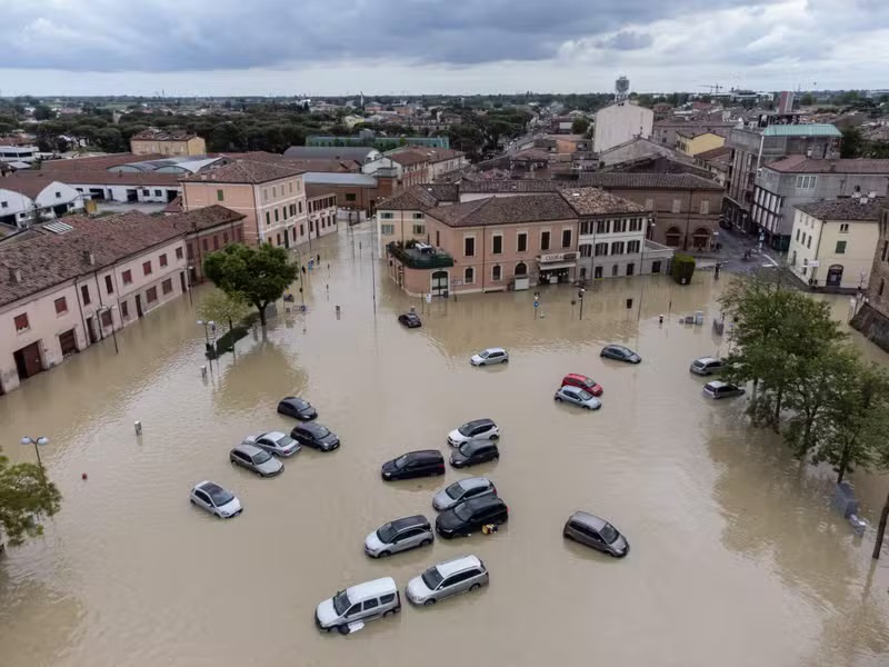
Devastation in Lugo, Italy, where streets turned into rivers. Could this have been anticipated? Credit: FEDERICO SCOPPA/AFP
The question is not if these events will happen again, but when. That’s why preparation is key, and it’s where the DEODE project steps in. Spearheaded by the European Centre for Medium-Range Weather Forecasts (ECMWF) and supported by the European Union, the project collaborates with partners across 22 countries, including myself from the Norwegian Meteorological Institute.
One of the most thrilling aspects of my role is working on digital twins powered by machine learning—complex models that learn from past data to improve future forecasts. In this post, I’ll highlight how these models operate and the life-saving potential they offer.

The DEODE framework. First, a global digital twin runs once a day. A triggering system uses its predictions to decide when an extreme weather digital twin should be triggered. In those cases, a regional digital twin at high spatial and temporal resolution runs to anticipate the exact location and time of the event. Post-processing is used to estimate the impacts of the event.
The DEODE approach
There are different approaches one can take to forecast and warn against weather extremes. The DEODE approach starts with a global digital twin that runs once a day that looks for weather extremes over Europe. This is a probabilistic model, suggesting various events as well as the probability that they will occur. A triggering system monitors the global digital twin, and categorizes weather events, based on the climatology of specific locations and time of the year. An extreme event in Norway might not be the same as an extreme event in Spain and vice versa. If an event is considered as an extreme, a regional digital twin of high spatial and temporal resolution is triggered to look closer at where and when it will occur. Based on that, a post-processing tool is used to estimate the impacts of the event.
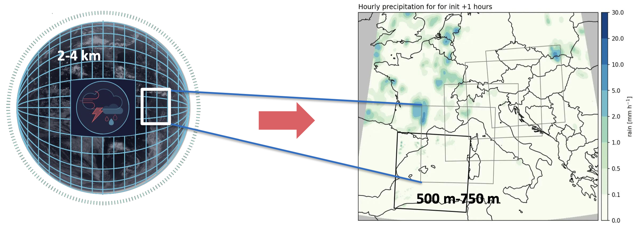
The extreme weather digital twin runs at high spatial and temporal resolution to monitor particular extreme events. Credit: Thomas Geenen/ECMWF
Why machine learning is the best solution
The recent progress in data-driven models for weather prediction has been impressive, and they often perform better than physics based numerical weather prediction (NWP) models. However, the accuracy itself is not the main reason why machine learning models is the better solution for the DEODE project. The time duration of generating a forecast is crucial, as the earlier we receive a forecast the earlier we can act on it. Once trained, machine learning models can provide a new forecast in mere seconds. This can easily be 100 times faster than the conventional NWP models. Machine learning models have also proved to be flexible, and are for instance capable of working with an arbitrary grid like discussed in a recent post.
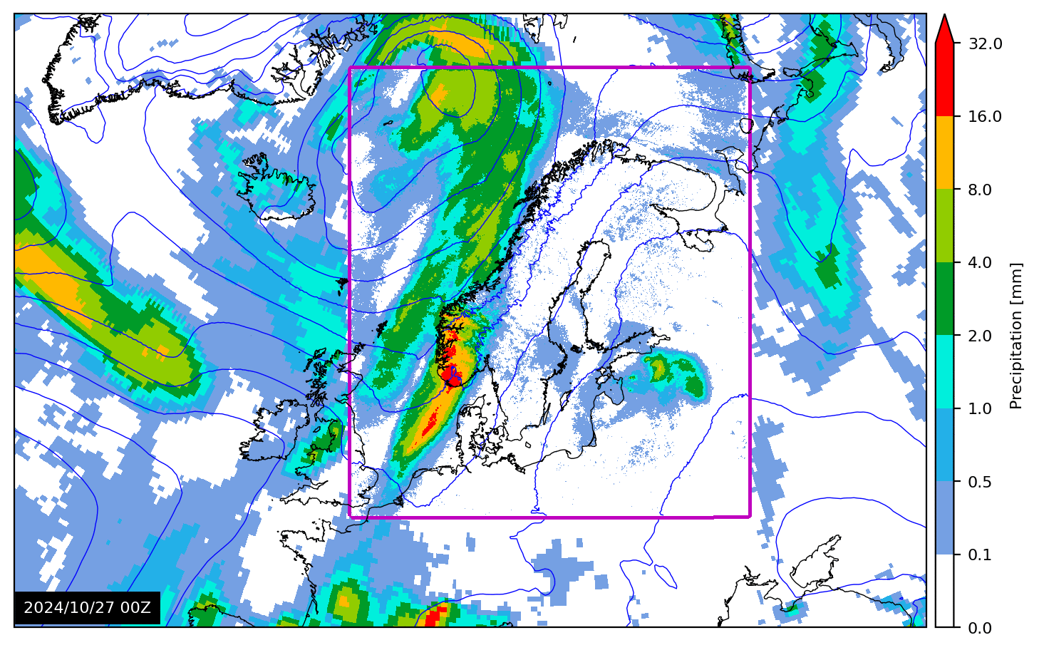
High resolution over the Nordics with a global stretched-grid. Seemless transition from low to high resolution. Credit: Magnus Ingstad/METNorway
Conclusions
So, here’s the game plan: a global digital twin tirelessly hunts for extreme weather across Europe. A precise, high-resolution twin is deployed to nail down the specifics—timing, location, and impact. The DEODE framework, still in its building phase, shows promise, and harnessing machine learning seems to be the shrewd route ahead.
Please check out our recent article on how the EuroHPC supercomputers are utilized to make the DEODE/DE330 project possible: T. Geenen et al., Towards full AI model lifecycle management on EuroHPC systems, experiences with AIFS for DestinE, Procedia Computer Science, 255 (2025)
Feel free to drop a comment or question below if you have thoughts or experiences you’d like to share.
